last update: Jul 16, 2025
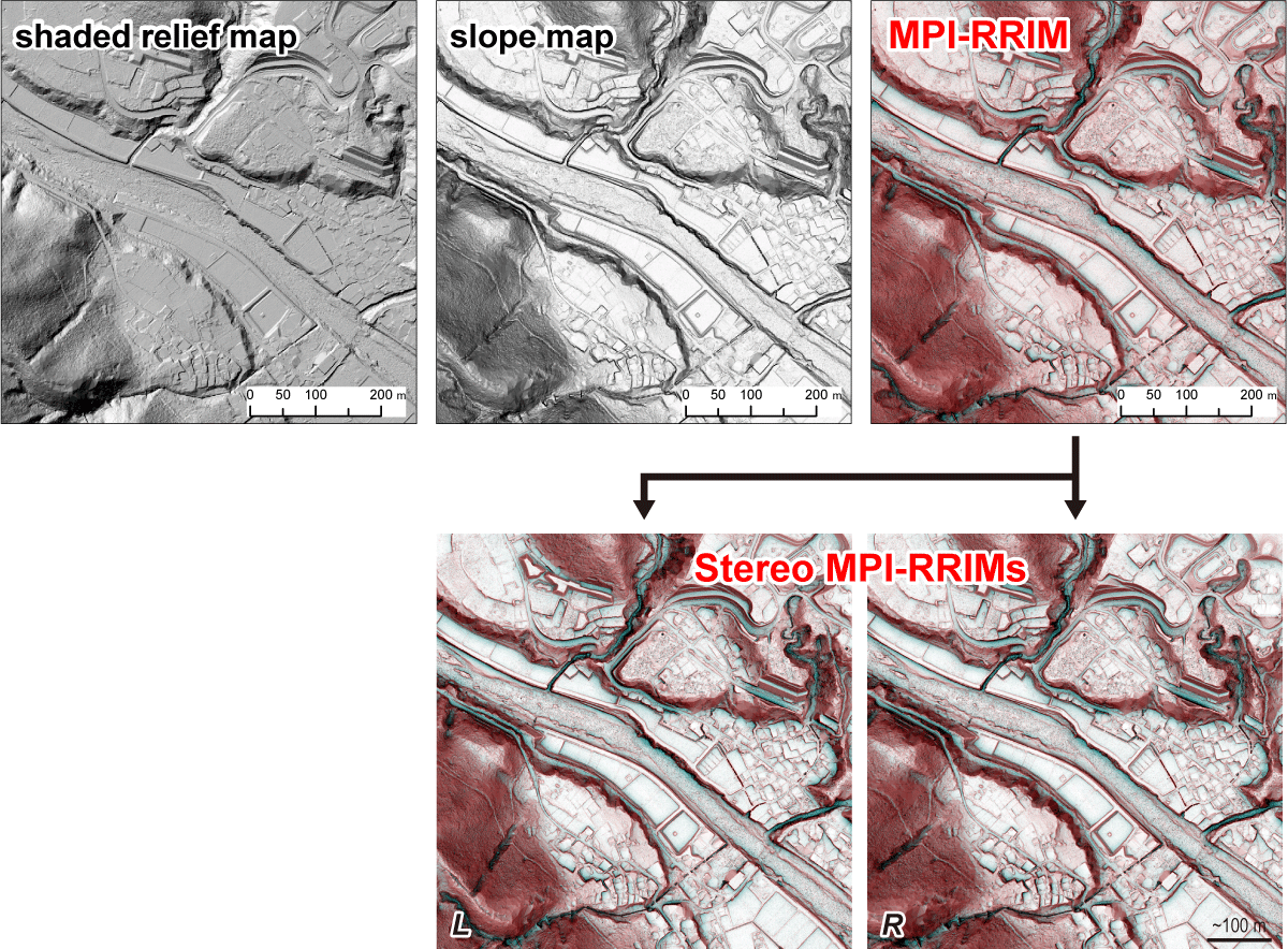
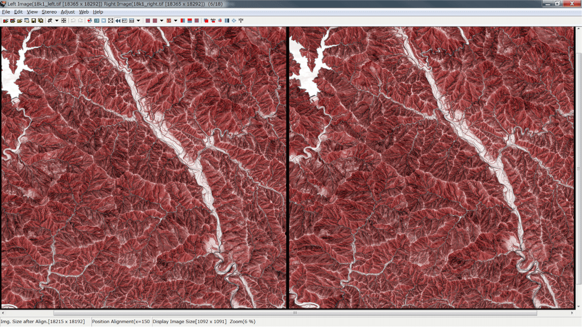
Stereopaired morphometric protection index (MPI) red relief image maps (Stereo MPI-RRIMs) are our proposed visualization of digital elevation models (DEMs), which are refined from an original red relief image map (RRIM; Chiba et al., 2008) to better fit to active-fault and other geomorphological studies. Unlike most often used shaded relief maps or slope maps, both of which only represent one aspect of topography, Stereo MPI-RRIMs allow simultaneous expression of the three important aspects of three dimensional morphology (elevation, slope, convexity/concavity) and would aid in more complete interpretation and mapping of small geomorphic features in the context of larger topography. See Kaneda and Chiba (2019) for more details of this visualization.
>> RRIM web site of the Asia Air Survey Co., Ltd.
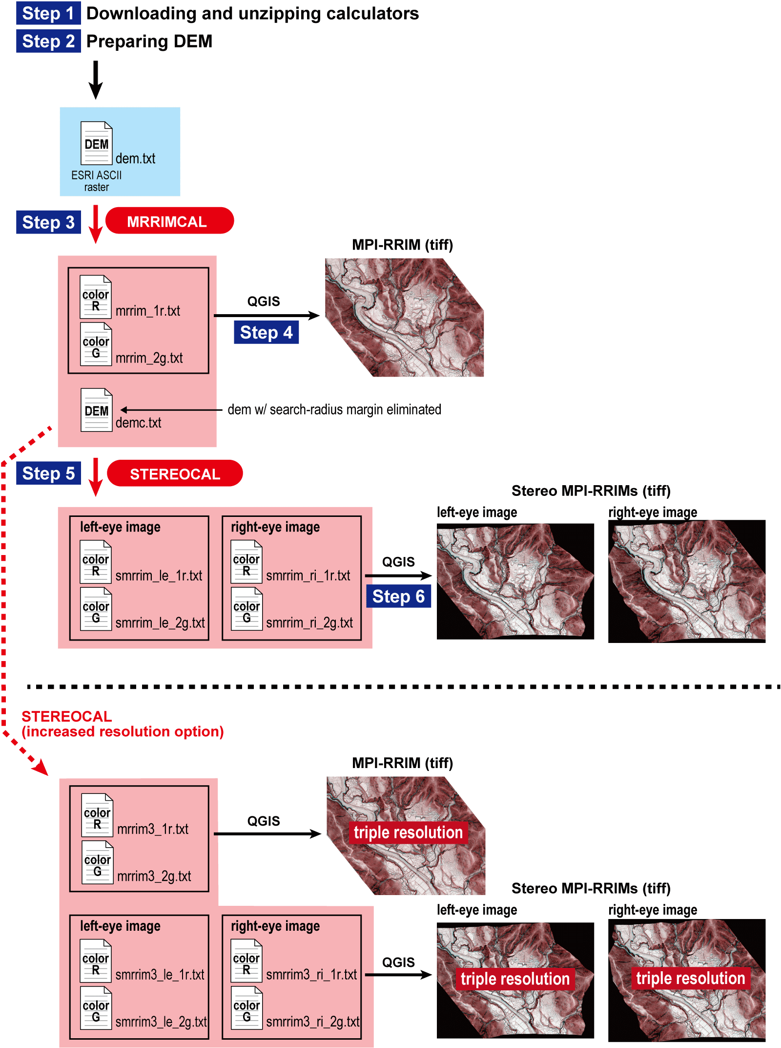
Below, a set of simple programs (Windows executable files) that calculate RGB color values of Stereo MPI-RRIMs is available. The programs do not require a software platform such as MATLAB, but GIS software such as QGIS is necessary to prepare the DEM and convert the output files to TIFF images. The "MRRIMCAL" executable file calculates color values of an (non-stereopaired) MPI-RRIM from a DEM with ESRI ASCII raster format, and "STEREOCAL" executable file calculates color values of Stereo MPI-RRIMs (for right and left eyes) from the output files of MRRIMCAL. For closer examination of geomorphic features with minimum degradation of original DEM quality, STEREOCAL has an option of producing Stereo MPI-RRIMs with the increased resolution by a factor of three. The color value files can be converted to tiff images by using GIS software such as QGIS.
NEW!
The calculation programs are now completely free of use and no longer require a password because the related patents of the Asia Air Survey Co., Ltd. have expired before 2024.
>> download calculators (zip; ~694 KB, only for Windows PC)
>> view user’s manual (pdf; ~1.1 MB) updated Jul 16, 2025
Citation note
If you publish your research that uses Stereo MPI-RRIMs visualization and/or our calculation programs, please cite only one paper below:
Kaneda, H., and T. Chiba (2019), Stereopaired morphometric protection index red relief image maps (Stereo MPI-RRIMs): effective visualization of high-resolution digital elevation models for interpreting and mapping small tectonic geomorphic features, Bull. Seismol. Soc. Am., 109, 99–109. https://doi.org/10.1785/0120180166
How to view stereopaired images
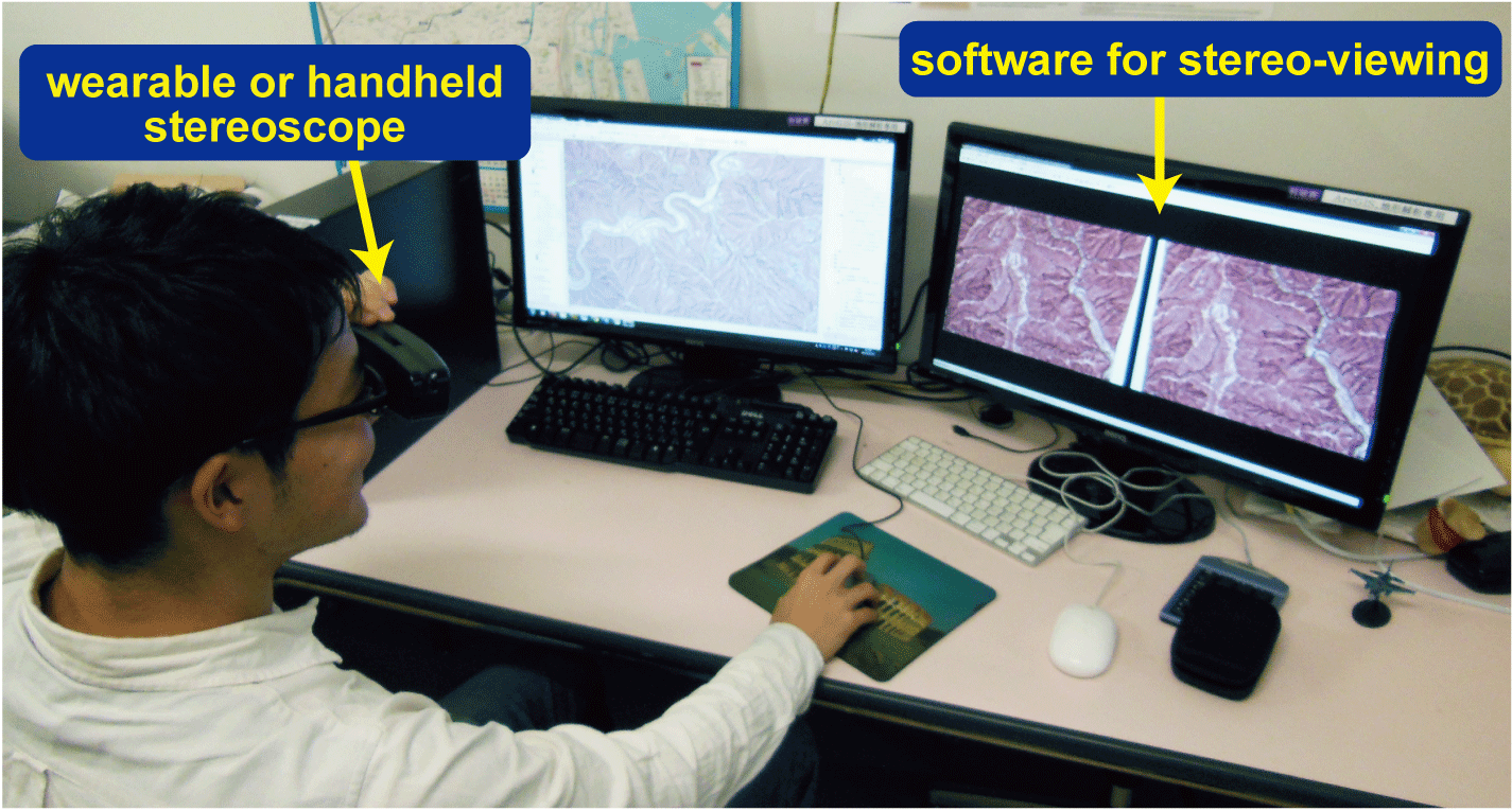
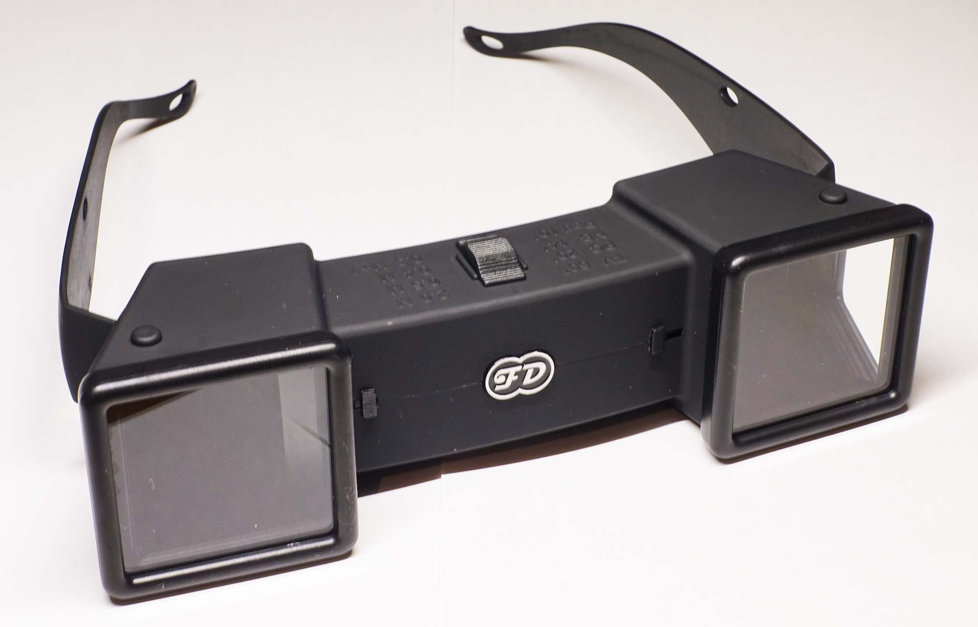
In order to take full advantage of Stereo MPI-RRIMs, we strongly recommend viewing the stereopaired images on a computer monitor, preferably on a large one, by using software that allows to show, move, enlarge, or reduce the two images simultaneously (such as free software StereoPhoto Maker) as well as a wearable or handheld stereoscope that supports stereo-viewing on a large monitor (such as Pocket 3Dvu of Berezin Stereo Photography Products). See appendix of the user's manual (pp. 14–16) for details of the software and stereoscope.
References
Chiba, T., Kaneta, S., and Suzuki, Y. (2008), Red relief image map: new visualization method for three dimensional data. The International Archives of the Photogrammetry, Remote Sensing and Spatial Information Sciences, 37(B2), 1071–1076.
Kaneda, H., and T. Chiba (2019), Stereopaired morphometric protection index red relief image maps (Stereo MPI-RRIMs): effective visualization of high-resolution digital elevation models for interpreting and mapping small tectonic geomorphic features, Bull. Seismol. Soc. Am., 109, 99–109. https://doi.org/10.1785/0120180166
>> back to HOME